Indian Journal of Science and Technology
DOI: 10.17485/IJST/v17i13.2588
Year: 2024, Volume: 17, Issue: 13, Pages: 1304-1314
Original Article
V Rajesh Kumar1,2*, S Guganesh1, D Hussain Babu1, P Kumaresan1
1Irrigation, Industrial and Infrastructure SBG, WET IC, L&T Construction, Chennai, TamilNadu, India
2DSc Research Scholar, Manipur International University, Manipur, India
*Corresponding Author
Email: [email protected]
Received Date:30 October 2023, Accepted Date:04 March 2024, Published Date:22 March 2024
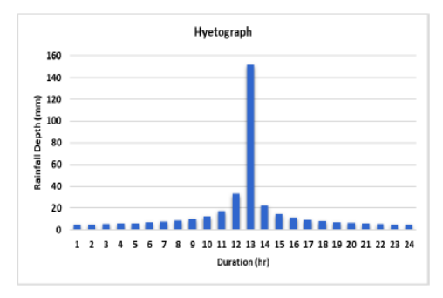
Objectives: Flood risk assessment is a fundamental aspect of disaster management, particularly in regions heavily reliant on irrigation infrastructure for agriculture. This study employs advanced hydrological and hydraulic modeling techniques to evaluate flood risk for the Lower Suktel region in Odisha, India. Methods: The methodology integrates Intensity-Duration-Frequency (IDF) curves, Isopluvial maps, and the Hydrologic Engineering Center-River Analysis System (HEC-RAS) to comprehensively analyze flood risk and its implications. Findings: IDF curves further reveal that the design rainfall intensity for a one-hour duration with a 100-year return period is 152 mm/h, aiding in characterizing rainfall intensity for specific return periods. Model simulation identifies the pump house's susceptibility to flooding, with maximum flood depths ranging from 0 to 2 meters. These findings underscore the significance of employing advanced modeling techniques and Isopluvial maps for precise flood risk assessment. Novelty: The novelty of this paper lies in its pioneering effort to introduce a comprehensive flood risk assessment in an area where it has not been previously conducted. The integration of advanced modeling techniques and spatial analysis tools contributes to the novelty of the research, making it a valuable and innovative contribution to the field of flood risk management. Understanding extreme rainfall events, hydraulic behavior, and potential flood depths is imperative for developing effective flood mitigation strategies.
Keywords: Flood risk assessment, Irrigation infrastructure, IDF curves, Hydrological modeling, Hydraulic modeling, GIS
© 2024 Kumar et al. This is an open-access article distributed under the terms of the Creative Commons Attribution License, which permits unrestricted use, distribution, and reproduction in any medium, provided the original author and source are credited. Published By Indian Society for Education and Environment (iSee)
Subscribe now for latest articles and news.


