Indian Journal of Science and Technology
Year: 2022, Volume: 15, Issue: 34, Pages: 1666-1674
Original Article
A Ibrahim1,2*, Diana Muhamad2, Nurwati Badarulzaman3
1Department of Urban & Regional Planning, Federal University Dutsin-Ma, Katsina State, Nigeria
2Ph.D. Student, School of Housing, Building & Planning, Universiti Sains, Penang Malaysia (USM)
3School of Housing, Building & Planning, Universiti Sains Penang Malaysia (USM)
*Corresponding Author
Email: [email protected]
Received Date:24 February 2022, Accepted Date:09 July 2022, Published Date:30 August 2022
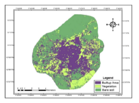
Objectives: To study the rapidly changing urban area of Katsina in Katsina State; Nigeria, to track Land Cover Changes (LCC) and to identify possible impacts of urbanization. Methods: Landsat thematic mapper (TM), enhance thematic mapper (ETM +) images 30m resolution from the United States Geological Survey (USGS) acquired from Jos National Centre for Remote Sensing (NCRS). Satellite images from 1999 and 2017 were used to create a past and current picture of the LCC in the urban area of Katsina. The images were classified using the pixel identity forms of the digital organization of the monitored images with a maximum-likelihood classifier algorithm based on the multispectral image to understand the spectral data presented in the image of the urban area of Katsina. These images were then compared with the modifications that occurred among the dates of images. Findings: The findings on study area showed that the built-up area had increased and added 4.99 square kilometres (percentage change of 22.22) between 1987 -1999. The class of vegetation/agricultural land cover also increased and added 10.4 square kilometres (percent change of 165.8) between 1987 -1999. The Bare-soil had decreased and lost 15.39 square kilometres (percent change of 25.29) between 1987 -1999. Conclusion: Land cover changes exist, either legal or illegal, which indicate the rapid rate of population growth and urbanization in the urban area of Katsina. It also revealed the capability of RS/GIS for managing large information that made it suitable for these types of study.
Keywords: Analysis; Based on the pixel individuality; Land Cover Changes (LCC); Monitoring and Urbanisation
© 2022 Ibrahim et al. This is an open-access article distributed under the terms of the Creative Commons Attribution License, which permits unrestricted use, distribution, and reproduction in any medium, provided the original author and source are credited.
Published By Indian Society for Education and Environment (iSee)
Subscribe now for latest articles and news.


