• P-ISSN 0974-6846 E-ISSN 0974-5645

Indian Journal of Science and Technology

Article

Indian Journal of Science and Technology

Year: 2022, Volume: 15, Issue: 35, Pages: 1691-1702

Original Article

Morphometric Analysis for Sustainable Development of Watersheds Using Multisensor Satellite Data: A Case Study from Shiriya River Basin

Received Date:09 May 2022, Accepted Date:31 July 2022, Published Date:07 September 2022

Abstract

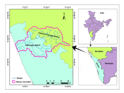
Objectives: The goal of this research is to calculate, compare and analyze the morphometric drainage parameters of Shiriya River Basin (SRB), Kasaragod, Kerala, using DEMs acquired by different satellite sensors and topographic data (SOI toposheet) for sustainable watershed development. Methods: The Arc GIS 10.3.1 software was used to measure linear, relief, and areal aspects of morphometry. The input data used for deriving the drainage network of the SRB were SOI toposheet (1:50000 scale), SRTM DEM (90m), Cartosat, ASTER and ALOS PALSAR DEM of resolution 30 m each. The relative error percentage of basic parameters derived from DEMs concerning the toposheet is calculated. A groundwater potential map is prepared using weighted overlay analysis of thematic layers (geology, geomorphology, slope, drainage density, lineament density and depth to water level). Findings: Present study revealed that the parameters derived from SRTM DEM data are more similar to those derived from toposheet. Most of the parameters obtained from each input DEM are more or less equal, and the minor variation may be due to varied data collecting and processing methodologies used for DEM creation. SRB is characterized by 6 th order stream with a dendritic drainage pattern, which is elongated and less susceptible to soil erosion. SRB has an intermediate texture and is in a mature stage of geomorphic evolution. Inference from the ground water potential zonation map indicates that major portion of the SRB has moderate ground water potential. Application/improvement: The study would be a valuable source for identifying water recharge sites, basin modelling, and groundwater prospect mapping. Novelty:This research has attempted to compare and analyze the morphometric parameters’ results from multisensor satellite data for sustainable watershed management. An attempt has been done to understand the relation between morphometric parameters and ground water potential of SRB using Groundwater potential zonation map.

Keywords: Drainage morphometry; Shiriya River basin; GIS; Karnataka; Kerala

References

  1. Esin Aİ, Akgul M, Akay AO, Yurtseven H. Comparison of LiDAR-based morphometric analysis of a drainage basin with results obtained from UAV, TOPO, ASTER and SRTM-based DEMs. Arabian Journal of Geosciences. 2021;14(5):1–5. Available from: https://doi.org/10.1007/s12517-021-06705-3
  2. Kasi V, Pinninti R, Landa SR, Rathinasamy M, Sangamreddi C, Kuppili RR, et al. Comparison of different digital elevation models for drainage morphometric parameters: a case study from South India. Arabian Journal of Geosciences. 2020;13(19):1–7. Available from: https://doi.org/10.1007/s12517-020-06049-4
  3. Jose C, Thomas J, Prasannakumar V, Reghunath R. BaDAM Toolbox: A GIS-Based Approach for Automated Drainage Basin Morphometry. Journal of the Indian Society of Remote Sensing. 2019;47(3):467–478. Available from: https://doi.org/10.1007/s12524-018-0913-9
  4. Praseeda E, Ganapathy GP. Neotectonic evidences associated with Achankovil shear zone using morphometric analysis and field investigations. Modeling Earth Systems and Environment. 2020;6(3):1487–1508. Available from: https://doi.org/10.1007/s40808-020-00765-2
  5. Strahler AN. Quantitative geomorphology of drainage basins and channel networks. (pp. 4-76) New York, McGraw-Hill book. 1964.
  6. Schumm SA. Evolution of drainage systems and slopes in Badlands at Perth Amboy, New Jersey. Bulletin of the Geological Society of America. 1956;67:597–646. Available from: https://doi.org/10.1130/0016-7606(1956)67[597:EODSAS]2.0.CO;2
  7. Strahler AN. DIMENSIONAL ANALYSIS APPLIED TO FLUVIALLY ERODED LANDFORMS. Geological Society of America Bulletin. 1958;69(3):279.
  8. Smith KG. Standards for grading texture of erosional topography. American Journal of Science. 1950;248(9):655–668. Available from: https://doi.org/10.2475/ajs.248.9.655
  9. Prakash K, Rawat D, Singh S, Chaubey K, Kanhaiya S, Mohanty T. Morphometric analysis using SRTM and GIS in synergy with depiction: a case study of the Karmanasa River basin, North central India. Applied Water Science. 2019;9(1). Available from: https://doi.org/10.1007/s13201-018-0887-3
  10. Singh AP, Arya AK, Singh DS. Morphometric Analysis of Ghaghara River Basin, India, Using SRTM Data and GIS. Journal of the Geological Society of India. 2020;95(2):169–178. Available from: https://doi.org/10.1007/s12594-020-1406-3
  11. Kudnar NS, Rajasekhar M. A study of the morphometric analysis and cycle of erosion in Waingangā Basin, India. Modeling Earth Systems and Environment. 2020;6(1):311–327. Available from: https://doi.org/10.1007/s40808-019-00680-1
  12. Adewole AO, Ike F, Eludoyin AO. A multi-sensor-based evaluation of the morphometric characteristics of Opa river basin in Southwest Nigeria. International Journal of Image and Data Fusion. 2020;11(2):185–200. Available from: https://doi.org/10.1080/19479832.2019.1683622
  13. Karabulut MS, Özdemir H. Comparison of basin morphometry analyses derived from different DEMs on two drainage basins in Turkey. Environmental Earth Sciences. 2019;78(18):1–4. Available from: https://doi.org/10.1007/s12665-019-8585-5
  14. Jain AO, Thaker TP, Misra AK, Singh AK, Kumari P. Determination of sensitivity of drainage morphometry towards hydrological response interactions for various datasets. Environment, Development and Sustainability. 2021;23(2):1799–1822. Available from: https://doi.org/10.1007/s10668-020-00652-x

Copyright

© 2022 Vidya & Manoharan. This is an open-access article distributed under the terms of the Creative Commons Attribution License, which permits unrestricted use, distribution, and reproduction in any medium, provided the original author and source are credited.

Published By Indian Society for Education and Environment (iSee)

DON'T MISS OUT!

Subscribe now for latest articles and news.