Indian Journal of Science and Technology
Year: 2024, Volume: 17, Issue: 24, Pages: 2547-2556
Original Article
Rimlee Bora1∗, Ashok Kumar Bora2
1Department of Earth Sciences, University of Science and Technology Meghalaya, 793101, Meghalaya, India
2Department of Geography, Gauhati University, Guwahati, 781014, Assam, India
*Corresponding Author
Email: [email protected]
Received Date:24 March 2024, Accepted Date:21 May 2024, Published Date:17 June 2024
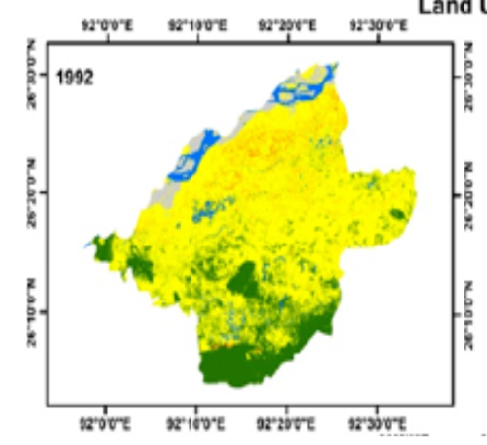
Objective: This study intends to prioritize the underlying mechanisms underpinning the spatial-temporal variations in Land Use and Land Cover (LULC) change in the Morigaon district, located in the middle part of Brahmaputra valley of Assam, India covering an area of 1498 km2.At the same time, this study focuses on the impact of population pressure on changing LULC in the study area. Methods: This research adopted geospatial approach for analysing land use land cover change in the study area. Satellite images from the years 1992 to 2022 have been utilized to identify the land transformation. The analysis of the land transformation has taken into account the five main LULC classifications of agriculture, forest, water bodies, built-up lands, and sand deposits. It has been discovered that the LULC classes identified in this study, which comprise both natural and anthropogenic elements, have a very strong link with the population growth in the Morigaon district. To show the relationship between population expansion and LULC indicators Pearson correlation method is used. Findings: Water bodies, forests and agriculture have significantly decreased by 0.13%, 4.66% and 1.64% respectively due to substantial anthropogenic activity during the past 30 years. In contrast, sand deposits and built-up lands increased by 3.13% and 3.30%. To show the relationship between population expansion and LULC indicators Pearson correlation method is used. Very significant relationships have been found between population and built-up lands with rho value 0.95. The relationship between population with agriculture, forest, water bodies and sand deposits have been seen with rho value -0.51, -0.89, -0.64 and 0.97 respectively. The loss of the geographic extent of natural classes like water bodies, forests, signifies that the geometrical progression in the human population has greatly amplified anthropogenic activities. Novelty: The novelty lies in adopting geospatial techniques that would certainly enhance land resource conservation. Environmental concerns have been increasing due to significant land surface change, which is predominantly the result of human-induced activities. In the studied area, socioeconomic, demographic, and proximity factors have a significant impact on the LULC change processes. The findings can be utilized to forecast potential LULC scenarios and offer direction for land management strategy.
Keywords: LULC, Satellite Images, Anthropogenic, Pearson Correlation, Proximity Factor
© 2024 Bora & Bora. This is an open-access article distributed under the terms of the Creative Commons Attribution License, which permits unrestricted use, distribution, and reproduction in any medium, provided the original author and source are credited. Published By Indian Society for Education and Environment (iSee)
Subscribe now for latest articles and news.


