Indian Journal of Science and Technology
Year: 2024, Volume: 17, Issue: 8, Pages: 713-722
Original Article
Farid Traoré1*, Sié Palé2, Aïda Zaré2, Moussa Karamoko Traoré1, Blaise Ouédraogo1, Joachim Bonkoungou1
1Institut de l’Environnement et de Recherches Agricoles, 04 BP 8645 Ouagadougou 04, Burkina Faso
2Université de Dédougou/Institut des Sciences de l’Environnement et du Développement Rural, BP 176 Dédougou, Burkina Faso
*Corresponding Author
Email: [email protected]
Received Date:10 January 2024, Accepted Date:08 February 2024, Published Date:14 February 2024
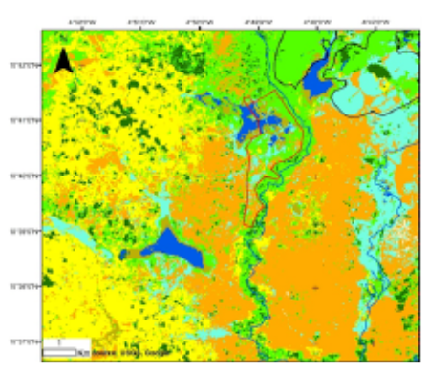
Objectives: This study investigates the performance of two machine-learning algorithms in classifying land areas across the Upper-Comoé basin in Burkina Faso. Methods: Within the Google Earth Engine data processing environment, Support Vector Machine (SVM) and the Random Forest (RF) algorithms were applied to a Landsat-8 OLI image of March 2019, to discriminate agricultural land areas, with an emphasis on irrigated areas. Findings: The results indicated good to excellent classification performance, with overall accuracies and Kappa coefficients between 71% and 99%, and 0.66 and 0.99, respectively. The RF method outperformed the SVM in terms of mapping "accuracy", but in terms of spatial distribution of classes, the SVM method provided a mapping close to reality, due to the density of the classes generated. Novelty: Our findings suggest that remote sensing can constitute a tool fully adapted to the needs of services in charge of agricultural water management in Burkina Faso.
Keywords: Irrigation, Random Forest, Support Vector Machine, Google Earth Engine, Burkina Faso
© 2024 Traoré et al. This is an open-access article distributed under the terms of the Creative Commons Attribution License, which permits unrestricted use, distribution, and reproduction in any medium, provided the original author and source are credited. Published By Indian Society for Education and Environment (iSee)
Subscribe now for latest articles and news.