• P-ISSN 0974-6846 E-ISSN 0974-5645

Indian Journal of Science and Technology

Article

Indian Journal of Science and Technology

Year: 2020, Volume: 13, Issue: 17, Pages: 1786-1794

Original Article

A novel pixel-based supervised hybrid approach for prediction of land cover from satellite imagery

Received Date:07 May 2020, Accepted Date:14 May 2020, Published Date:15 June 2020

Abstract

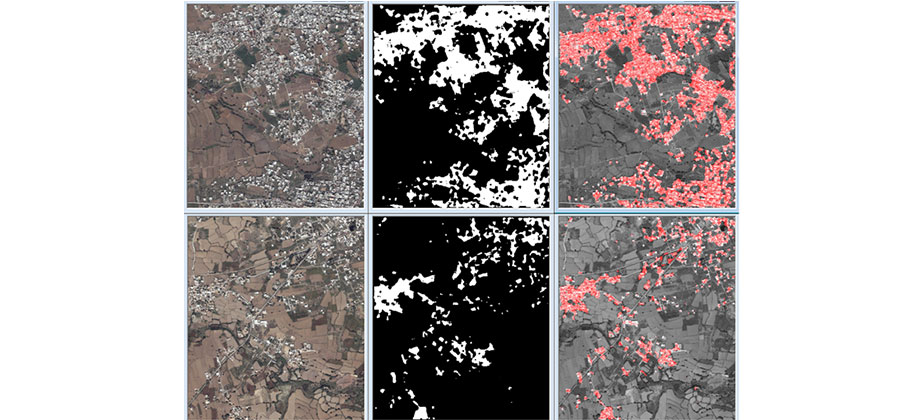
Background/Objectives: To determine the land use/cover from satellite imagery using image enhancement, image processing, and supervised machine learning techniques. This land usage will help in land use policy development, disaster assessment, planning of urban infrastructure, forest and agriculture monitoring and conservation. Methods/Statistical analysis: A pixel-based supervised hybrid machine learning approach is used that combines parametric density estimation followed by a k-nearest neighbor (k-NN) classifier to predict whether a particular pixel belongs to a nucleated village or to a field, forest, river, or some other terrain from satellite images. Spatial and texture features derived from the images are used as features for the models. Free satellite images crawled from Google EarthTM are hand labeled to serve as the ground truth for training and testing Models. Models are evaluated using four-fold cross validation. Comparison with other related techniques is also presented. Findings: Our experiments suggest that instead of using pixel intensity values as features, the intensity values after edge detection give better prediction accuracy. The parametric density estimation for the two classes is better modeled as Rayleigh distribution than as a normal distribution. Smoothing further helps improve the accuracy of the models. Passing the prediction of the parametric density estimator classifier through k-NN further reduces the error by removing the salt-and-pepper effects. Effects of using different size and number of smoothing filters is also discussed. Additionally, different parameters for k-NN were also evaluated to find the best models. The model was successful in achieving a very high accuracy of more than 97% with a very small false positive rate. The results demonstrate the successful discrimination of land cover of towns and nucleated villages from the surrounding terrain. Novelty/Applications: A pixel-based hybrid approach is proposed to improve accuracy of land cover classification. The proposed features and image enhancement techniques also help improve the prediction significantly. Using the proposed technique, the covered area of nucleated villages/towns can be determined for assessing the growth of towns/villages, for better of planning of urban infrastructure and land use policy, for disaster assessment, and forest and agriculture monitoring and conservation.

Keywords: Land cover classification; land usage classification; satellite image classification; nucleated village segmentation 

References

  1. Haack BN. Landsat: A tool for development. World Development. 1982. Available from: https://doi.org/10.1016/0305-750X(82)90064-X
  2. Martins V, Barbosa C, Carvalho Ld, Jorge D, Lobo F, Novo E. Assessment of Atmospheric Correction Methods for Sentinel-2 MSI Images Applied to Amazon Floodplain Lakes. Remote Sensing. 2017;9(4):322. Available from: https://doi.org/10.3390/rs9040322
  3. Zhu Z, Zhang J, Yang Z, Aljaddani AH, Cohen WB, Qiu S, et al. Continuous monitoring of land disturbance based on Landsat time series. Remote Sensing of Environment. 2020. Available from: https://doi.org/10.1016/j.rse.2019.03.009
  4. Helber P, Bischke B, Dengel A, Borth D. EuroSAT: A Novel Dataset and Deep Learning Benchmark for Land Use and Land Cover Classification. IEEE Journal of Selected Topics in Applied Earth Observations and Remote Sensing. 2019;12(7):2217–2226. doi: 10.1109/jstars.2019.2918242
  5. Tailor AM, Corr DG, Cross A, Hogg DC, Lawrence DH, Mason DC, et al. Development of a knowledge-based segmentor for remotely sensed images. Philosophical Transactions of the Royal Society of London. Series A Mathematical and Physical Sciences. 1988;324(1579):437–483. Available from: https://doi.org/10.1098/rsta.1988.0031
  6. Moorthi SM, Misra I, Kaur R, Darji NP, Ramakrishnan R. Kernel based learning approach for satellite image classification using support vector machine. 2011 IEEE Recent Advances in Intelligent Computational Systems. 2011;p. 107–110. Available from: https://doi.org/10.1109/RAICS.2011.6069282
  7. Abburu S, Golla SB. Satellite Image Classification Methods and Techniques: A Review. International Journal of Computer Applications. 2015;119(8):20–25. Available from: https://doi.org/10.5120/21088-3779
  8. Yan G, Mas J‐, Maathuis BHP, Xiangmin Z, Dijk PMV. Comparison of pixel‐based and object‐oriented image classification approaches—a case study in a coal fire area, Wuda, Inner Mongolia, China. International Journal of Remote Sensing. 2006;27(18):4039–4055. Available from: https://dx.doi.org/10.1080/01431160600702632
  9. Kiani A, Ahmadi FF, Ebadi H. Developing an Interpretation System for High-Resolution Remotely Sensed Images Based on Hybrid Decision-Making Process in a Multi-scale Manner. Journal of the Indian Society of Remote Sensing. 2020;48(2):197–214. Available from: https://dx.doi.org/10.1007/s12524-019-01069-4
  10. Mota GLA, Feitosa RQ, Coutinho HLC, Liedtke CE, Müller S, Pakzad K, et al. Multitemporal fuzzy classification model based on class transition possibilities. ISPRS Journal of Photogrammetry and Remote Sensing. 2007;62(3):186–200. doi: 10.1016/j.isprsjprs.2007.04.001
  11. Berhane T, Lane C, Wu Q, Anenkhonov O, Chepinoga V, Autrey B, et al. Comparing Pixel- and Object-Based Approaches in Effectively Classifying Wetland-Dominated Landscapes. Remote Sensing. 2017;10(1):46. doi: 10.3390/rs10010046
  12. Clevers J, Kooistra L, Brande Mvd. Using Sentinel-2 Data for Retrieving LAI and Leaf and Canopy Chlorophyll Content of a Potato Crop. Remote Sensing. 2017;9(5):405. Available from: https://doi.org/10.3390/rs9050405
  13. Basu S, Ganguly S, Mukhopadhyay S, Dibiano R, Karki M, Nemani R. Deepsat: a learning framework for satellite imagery. In: Proceedings of the 23rd SIGSPATIAL international conference on advances in geographic information systems. (pp. 1-10) 2015.
  14. Ienco D, Gaetano R, Dupaquier C, Maurel P. Land Cover Classification via Multitemporal Spatial Data by Deep Recurrent Neural Networks. IEEE Geoscience and Remote Sensing Letters. 20178;14(10):1685–1689. doi: 10.1109/LGRS.2017.2728698
  15. Lopes M, Frison P, Crowson M, Warren‐Thomas E, Hariyadi B, Kartika WD, et al. Improving the accuracy of land cover classification in cloud persistent areas using optical and radar satellite image time series. Methods in Ecology and Evolution. 2020;11(4):532–541. Available from: https://doi.org/10.1111/2041-210X.13359
  16. Otukei JR, Blaschke T, Collins M. Fusion of TerraSAR-x and Landsat ETM+ data for protected area mapping in Uganda. International Journal of Applied Earth Observation and Geoinformation. 2015;38:99–104. Available from: https://doi.org/10.1016/j.jag.2014.12.012

Copyright

© 2020 Junejo. This is an open access article distributed under the terms of the Creative Commons Attribution License, which permits unrestricted use, distribution, and reproduction in any medium, provided the original author and source are credited.

Published By Indian Society for Education and Environment (iSee)

DON'T MISS OUT!

Subscribe now for latest articles and news.