Indian Journal of Science and Technology
DOI: 10.17485/ijst/2016/v9i28/98393
Year: 2016, Volume: 9, Issue: 28, Pages: 1-6
Original Article
Virrat Devaser and Ashish Kr. Luhach*
School of Computer Science and Engineering, [email protected]
[email protected]
*Author for correspondence
Ashish Kr. Luhach
School of Computer Science and Engineering
Email:[email protected]
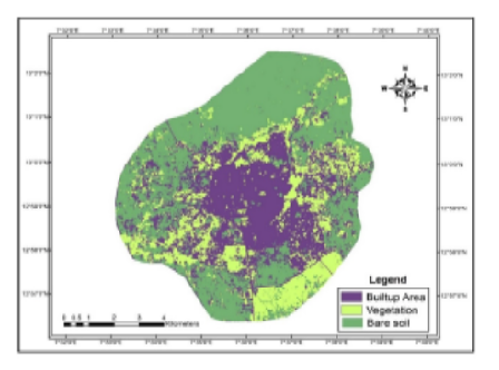
Background/Objective: Crop acreage and production estimate is of great challenge and requires strategic decisions to be taken by government agencies regarding controlling import and export duties and also to control inflation as a whole. Methods/Statistical Analysis: A lot of techniques exist to measures the yield and production for a given area and that too crop wise. We estimate the crop acreage with the help of remote sensing data and geographic information system techniques. In remote sensing, we acquire information related to the earth surface and to determine the crop acreage with the help of remote sensing images. We extract the useful information related to the yield estimation. Findings: In image processing, it is used to analyze or manipulate the features of an image. We used K-mean clustering and Self Organizing Map algorithms here for the crop Acreage and production estimation as a comparative approach to measure out acreage for a specific area image. By applying different image processing techniques and using the remote sensing techniques we estimated the production estimates for crops and compared the results with actual data obtained from statistical sources. Geographic Information System is widely used in crop acreage and production estimation to find out the locations of a particular image and helps in improving the accuracy of estimates. The challenge still remained regarding the crop segregation which requires lot of ground truth validation and hence makes the approach less viable as it reduces accuracy. Self organizing maps were found to be giving better results than other approaches. Applications/Improvement: It can be used by government agencies for taking decisions regarding import/export duty control and by agencies interested in procurement of crops and can be used by RBI to tackle Inflation as well.
Keywords: Remote Sensing, Geographic Information System, Un Supervised Classification, K Means, SOM Algorithm, Supervised Classification
Subscribe now for latest articles and news.