Indian Journal of Science and Technology
DOI: 10.17485/IJST/v13i33.1115
Year: 2020, Volume: 13, Issue: 33, Pages: 3430-3444
Original Article
Rajashree Boruah1, Binod Kumar Nath2, Debashree Borah3*
1Trainee, Rajiv Gandhi University, Arunachal Pradesh
2Modern Survey Faculty, Assam Survey and Settlement Training Centre, Guwahati
3Research Scholar, Gauhati University, Guwahati, Tel.: 8011118871
*Corresponding Author
Tel: 8011118871
Email: [email protected]
Received Date:03 August 2020, Accepted Date:16 August 2020, Published Date:11 September 2020
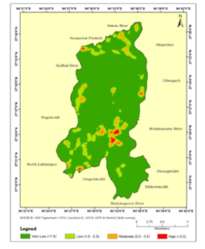
Background: Land of monsoons, India has been triggered by flood and siltation annually through south-west and north-east monsoons along the floodplains of the country for millennia. Being one of the worst sufferers, Assam also experiences the severe effects of flood hazard as the region is drained by the mighty Brahmaputra and Barak basins. In this view, Dhemaji district located in the upper reach of Brahmaputra valley also bears the brunt of flood leaving massive imprints on people and landscape. Objective: This study is an attempt to identify the flood vulnerable zones and damages incurred in a flood period of Dhemaji revenue circle. Methodology: The study is based on both primary and secondary sources of information wherein the data and maps have been processed and prepared within the domain of GIS and remote sensing. Findings: The results indicate that the entire region is categorized into two flood hazard zones viz. least and highly vulnerable wherein the former covers 55.27% and latter 44.73% of the total area. The damages caused in respect to cropland and transportation network have also been estimated and few management strategies were recommended to cope with the hazard. Novelty: The existing work has used various physical factors wherein priority ranks are allotted to each based on their intensity towards flood occurrence. Thus, this study would help in identification of potential hazard zones and affected areas through mapping and modeling using geospatial techniques which are cost and time effective.
Keywords: Flood hazard; Brahmaputra valley; assessment; management; GIS;remote sensing
© 2020 Boruah et al.This is an open-access article distributed under the terms of the Creative Commons Attribution License, which permits unrestricted use, distribution, and reproduction in any medium, provided the original author and source are credited. Published By Indian Society for Education and Environment (iSee).
Subscribe now for latest articles and news.


