• P-ISSN 0974-6846 E-ISSN 0974-5645

Indian Journal of Science and Technology

Article

Indian Journal of Science and Technology

Year: 2021, Volume: 14, Issue: 9, Pages: 810-825

Original Article

Application of remote sensing in mapping hydrothermally altered zones in a highly vegetative area - A case study of Lolgorien, Narok County, Kenya

Received Date:13 January 2021, Accepted Date:28 February 2021, Published Date:23 March 2021

Abstract

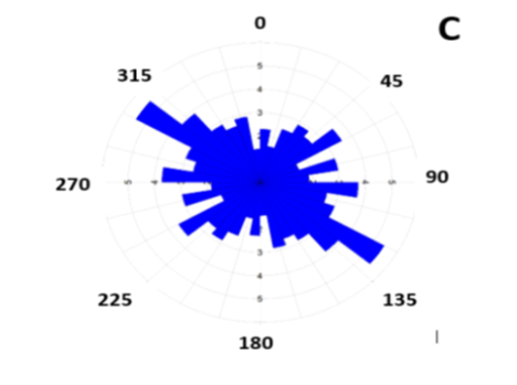
Objective: To map areas of possible hydrothermal alteration using remote sensing technology; To map geological structures controlling mineralisation using remote sensing; To carryout field mapping to ground truth the features identified by remote sensed data. Methods: Landsat 8 Operational Land Imager (OLI) and Shuttle Radar Topography Mission (SRTM) remote sensed images were downloaded from USGS website. Landsat images were processed using band ratios, band composites, principal component analysis techniques in ArcGIS to map areas of possible hydrothermal alteration. SRTM image was analysed using hillshade analysis technique in ArcGIS to map geological structural features controlling mineralisation. Findings: The study found that in several areas especially Southern, South Eastern, Central and North Western part of Lolgorien, there is a possibility of hydrothermal alteration as spectral signatures associated with iron oxide and clay minerals were identified. It was also found that areas with possibility of hydrothermal alteration are also associated with relatively large number of lineaments. It was also found that Southern and South-Eastern part of Lolgorien are also associated with numerous artisanal mines proving the fact that indeed gold mineralisation may be found in these places. However, due to thick vegetation cover, mapping of different types of lithological units found in Lolgorien was not possible. Novelty/Application: The application of remote sensed technology helped in identification of new areas of possible mineralisation such as Central and North-Western parts of Lolgorien which despite having similar geological properties (in terms of lineament density and hydrothermal alteration) have never been exploited for gold or other minerals.

Keywords: Hydrothermal alteration; Landsat 8 (OLI); SRTM; Iron oxide; clay minerals; remote sensing

References

  1. Kotnise G, Chennabasappa S. Application of remote sensing techniques in identification of lithological rock units in southern extension of Kolar Schist Belt from Chigargunta. International Journal of Innovative Science, Engineering & Technology. 2015;2(11).
  2. Drews-Armitage SP, Romberger SB, Whitney CG. Clay alteration and gold deposition in the Genesis and Blue Star deposits, Eureka County, Nevada. Economic Geology. 1996;91(8):1383–1393. Available from: https://dx.doi.org/10.2113/gsecongeo.91.8.1383
  3. Mahboob MA, Genc B, Celik T, Ali S, Atif I. Mapping hydrothermal minerals using remotely sensed reflectance spectroscopy data from Landsat. Journal of the Southern African Institute of Mining and Metallurgy. 2019;119(3):249–89. Available from: https://dx.doi.org/10.17159/2411-9717/2019/v119n3a7
  4. Amara BN, Aissa DE, Maouche S, Braham M, Machane D, Guessoum N. Hydrothermal alteration mapping and structural features in the Guelma basin (Northeastern Algeria): contribution of Landsat-8 data. Arabian Journal of Geosciences. 2019;12(3):94. Available from: https://dx.doi.org/10.1007/s12517-019-4224-4
  5. Liu L, Li Y, Zhou J, Han L, Xu X. Gold-copper deposits in Wushitala, Southern Tianshan, Northwest China: Application of ASTER data for mineral exploration. Geological Journal. 2018;53:362–371. Available from: https://doi.org/10.1002/gj.2989
  6. Sutton M, Weiersbye I, Galpin J, Heller D, Fourie A, Tibbett M. A GIS-based history of gold mine residue deposits and risk assessment of post-mining land uses on the Witwatersrand Basin, South Africa. In: Mine Closure 2006. (pp. 667-678) 2006.
  7. Pour AB, Park Y, Crispini L, Läufer A, Hong JK, Park TYS, et al. Mapping Listvenite Occurrences in the Damage Zones of Northern Victoria Land, Antarctica Using ASTER Satellite Remote Sensing Data. Remote Sensing. 2019;11(12). Available from: https://dx.doi.org/10.3390/rs11121408
  8. Sekandari M, Masoumi I, Pour AB, Muslim AM, Rahmani O, Hashim M, et al. Application of Landsat-8, Sentinel-2, ASTER and WorldView-3 Spectral Imagery for Exploration of Carbonate-Hosted Pb-Zn Deposits in the Central Iranian Terrane (CIT) Remote Sensing. 2020;12:1239. Available from: https://dx.doi.org/10.3390/rs12081239
  9. Bolouki SM, Ramazi HR, Maghsoudi A, Pour AB, Sohrabi G. A Remote Sensing-Based Application of Bayesian Networks for Epithermal Gold Potential Mapping in Ahar-Arasbaran Area, NW Iran. Remote Sensing. 2019;12. Available from: https://dx.doi.org/10.3390/rs12010105
  10. Zoheir B, El-Wahed MA, Pour AB, Abdelnasser A. Orogenic Gold in Transpression and Transtension Zones: Field and Remote Sensing Studies of the Barramiya–Mueilha Sector, Egypt. Remote Sensing. 2019;11(18):2122. Available from: https://dx.doi.org/10.3390/rs11182122
  11. Zoheir B, Emam A, Abdel-Wahed M, Soliman N. Multispectral and Radar Data for the Setting of Gold Mineralization in the South Eastern Desert, Egypt. Remote Sensing. 2019;11(12). Available from: https://dx.doi.org/10.3390/rs11121450
  12. Ichang’i D, Maclean W. The Archean volcanic facies in the Migori segment. J Afr Earth Sci. 1991;13(3/4):277–290.
  13. Shackleton R. Geology of the Migori gold belt. Geol Surv Kenya. 1946;10.
  14. Goetz A. Three decades of hyperspectral remote sensing of the Earth: A personal view. Remote Sensing of Environment. 2009;113:5–16. Available from: https://doi.org/10.1016/j.rse.2007.12.014
  15. Carranza EJM, Hale M. Mineral imaging with Landsat Thematic Mapper data for hydrothermal alteration mapping in heavily vegetated terrane. International Journal of Remote Sensing. 2002;23:4827–4852. Available from: https://dx.doi.org/10.1080/01431160110115014

Copyright

© 2021 Ombiro et al.This is an open access article distributed under the terms of the Creative Commons Attribution License, which permits unrestricted use, distribution, and reproduction in any medium, provided the original author and source are credited. Published By Indian Society for Education and Environment (iSee)

DON'T MISS OUT!

Subscribe now for latest articles and news.