• P-ISSN 0974-6846 E-ISSN 0974-5645

Indian Journal of Science and Technology

Article

Indian Journal of Science and Technology

Year: 2022, Volume: 15, Issue: 47, Pages: 2646-2661

Original Article

Identification of Suitable Sites for Rainwater Harvesting Using GIS in Kandahar Province, Afghanistan

Received Date:11 July 2021, Accepted Date:17 November 2022, Published Date:21 December 2022

Abstract

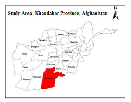
Objectives: This study aims to identify the potential areas for rainwater harvesting in Kandahar, Afghanistan. Methods: This study used GIS-based RS techniques. Satellite images were used to plan multiple thematic layers, such as lithology, slope, land use/cover, stream order, and soil texture. These layers were then converted into raster data using the raster converter feature of the ArcGIS 10.4 program. In order to come up with a site suitability map for water harvesting structure, multicriteria analysis was then carried out on the different layers, each layer’s characteristics were assigned weights as provided by experts in past research reviews. Owing to their power and their respective class weights, different layers were then overlaid. Findings: The findings showed that the catchment was grouped into categories as ’high’, ‘moderate’ and ‘low’ zones with regard to the allocated weighting of different thematic layers using weighted overlay. Twenty zones of rainwater harvesting structures were identified from the WH suitability map for the various structures for water harvesting. The suitability map helped to select water harvesting structures such as percolation tanks, storage tanks, control dams, and stop dams to be installed at the different identified sites. The potential sites of rain water harvesting identified were Shorabak, Boldak, Marrurf, Arghistan-1, Arghistan- 2, Arghistan-3, Khakres, Ghorak, Maiwand-1 and Maiwand-2 in the Kandahar Province Afghanistan. Novelty: These findings indicate that high potential zones would play a key role in the future expansion of the production of drinking water and irrigation in the study region. The suitability map is useful to hydrologists, decision-makers, and planners for quickly identifying areas with the highest potential for harvesting rainwater. Keywords: Rainwater harvesting; ground water; AHP approach; GIS; Kandahar; Afghanistan

References

  1. Cosgrove WJ, Loucks DP. Water management: Current and future challenges and research directions. Water Resources Research. 2015;51(6):4823–4839. Available from: https://doi.org/10.1002/2014WR016869
  2. Gleick PH. Water and Conflict: Fresh Water Resources and International Security. International Security. 1993;18(1):79. Available from: https://doi.org/10.2307/2539033
  3. Raleigh C, Urdal H. Climate change, environmental degradation and armed conflict. Political Geography. 2007;26(6):674–694. Available from: https://doi.org/10.1016/j.polgeo.2007.06.005
  4. Stenseth NC, Ottersen G, Hurrell JW, Mysterud A, Lima M, Chan K, et al. Review article. Studying climate effects on ecology through the use of climate indices: the North Atlantic Oscillation, El Niño Southern Oscillation and beyond. Proceedings of the Royal Society of London. Series B: Biological Sciences. 2003;270(1529):2087–2096. Available from: https://doi.org/10.1098/rspb.2003.2415
  5. Dunnett N, Clayden A. Rain Gardens: Managing water sustainably in the garden designed landscape. Timber Press, Inc. 2007.
  6. Maier R, Krebs G, Pichler M, Muschalla D, Gruber G. Spatial Rainfall Variability in Urban Environments—High-Density Precipitation Measurements on a City-Scale. Water. 2020;12(4):1157. Available from: https://doi.org/10.3390/w12041157
  7. Ahmed Z, et al. Hydrogeophysical investigation for groundwater potential through Electrical Resistivity Survey in Islamabad, Pakistan. Journal of Geography and Social Sciences. 2020;2020(2):147–163.
  8. Saqib SE, Ahmad MM, Panezai S, Rana IA. An empirical assessment of farmers' risk attitudes in flood-prone areas of Pakistan. International Journal of Disaster Risk Reduction. 2016;18:107–114. Available from: https://doi.org/10.1016/j.ijdrr.2016.06.007
  9. Saqib SE, Ahmad MM, Panezai S, Hidayatullah H, Khattak KK. Access to Credit and its Adequacy to Farmers in Khyber Pakhtun-khwa: The Case of Mardan District. Sarhad Journal of Agriculture. 2016;32(3):184–191. Available from: http://dx.doi.org/10.17582/journal.sja/2016.32.3.184.191
  10. Khan IA, Rafiq M, Panezai S, Saqib SE, Ullah R, Atiq M. How do farmers cope with climate change? An analysis of alternative adaptation strategies in drought-hit areas of Khyber Pakhtunkhwa—Pakistan. Natural Hazards. 2022;112(3):2259–2275. Available from: https://doi.org/10.1007/s11069-022-05264-4
  11. Saqib S, et al. The Effects of Education, Experience and Skill on Individuals’ Earning: Empirical Evidence from Khyber Pakhtunkhwa,Pakistan. International Journal of Advanced Multidisciplinary Social Science. 2016;2(1):27–32. Available from: https://doi.org/10.5923/j.jamss.20160201.03
  12. Danish MSS, Senjyu T, Sabory NR, Danish SMS, Ludin GA, Noorzad AS, et al. Afghanistan's aspirations for energy independence: Water resources and hydropower energy. Renewable Energy. 2017;113:1276–1287. Available from: https://doi.org/10.1016/j.renene.2017.06.090
  13. Winpenny J. RD., ed. Managing Water as an Economic Resource. Routledge. 2005.
  14. Rakhmatullaev S, Huneau F, Kazbekov J, Coustumer PL, Jumanov J, Oifi BE, et al. Groundwater resources use and management in the Amu Darya River Basin (Central Asia) Environmental Earth Sciences. 2010;59(6):1183–1193. Available from: https://doi.org/10.1007/s12665-009-0107-4
  15. Rahmani S, Akramzoi I, Mihara M. Water Harvesting Potential and its Maximization by the Application of Clayey Dressing in Qargha Reservoir Watershed. International Journal of Environmental Rural Development. 2021;12(2):116–121. Available from: https://iserd.net/ijerd122/12-2-18.pdf
  16. Louhaichi M, Hassan S, Gamoun M, Safi N, Abdallah MAB, Ates S. Evaluation of rainwater harvesting and shrub establishment methods for sustainable watershed management in northern Afghanistan. Journal of Mountain Science. 2022;19(8):2346–2359. Available from: https://doi.org/10.1007/s11629-021-7172-x
  17. Wikipedia. Kandahar Population. 2022.
  18. CDM. Kandahar Groundwater Resource Assessment. Contract. 2003;(806).
  19. The Study on Urgent Rehabilitation Support Program of Agriculture in Kandahar. Afghanistan: Final Report. Japan International Cooperation Agency. 2004.
  20. Bazai MH, Panezai S. Assessment of urban sprawl and land use change dynamics through GIS and remote sensing in Quetta. Journal of Geography and Social Sciences. 2020;2020(1):31–50.
  21. Khan Z, Saeed A, Bazai MH. Land use/land cover change detection and prediction using the CA-Markov model: A case study of Quetta city,Pakistan. Journal of Geography and Social Sciences. 2020;p. 164–182.
  22. Rahimi O, Murakami KJ土G. Rooftop rainwater harvesting and its efficiency in Kabul new city. Journal of Japan Society of Civil Engineers, Ser. G (Environmental Research). 2017;73(5):I_25–I_30.
  23. Ullah H. Decline of Static Water Level in Quetta Sub-basin. Journal of Geography and Social Sciences. 2021;3(1):1–16.

Copyright

© 2022 Haziq & Ibrahimi.  This is an open-access article distributed under the terms of the Creative Commons Attribution License, which permits unrestricted use, distribution, and reproduction in any medium, provided the original author and source are credited. Published By Indian Society for Education and Environment (iSee)

DON'T MISS OUT!

Subscribe now for latest articles and news.