Indian Journal of Science and Technology
Year: 2023, Volume: 16, Issue: 18, Pages: 1340-1348
Original Article
Lalit M Thakare1*, Tushar A Shitole2
1Department of Geography, Sir Parashurambhau College, Pune, 411030, Maharashtra, India
2Department of Geography, S. Bhelke College, Nasrapur, Pune, 412213, Maharashtra, India
*Corresponding Author
Email: [email protected]
Received Date:22 January 2023, Accepted Date:08 April 2023, Published Date:05 May 2023
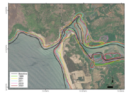
Objectives: To ascertain the shoreline changes along south Konkan region, Sindhudurg district, along the west coast of India. Methods: The Shoreline Change Detection Analysis (SCDA) was executed by field excursions, GPS surveys, cross-profiling and using satellite data. Toposheets were used for preparing a base map. GPS positions were marked at each location of measurement while surveying. Recorded data were cross-verified and compared with MMB bathymetric charts. Geometrically corrected Landsat imageries from 1991–2022 were used and extraction of the coastlines was performed. This satellite image data were georeferenced and the shorelines were extracted and digitized. The LRR statistical reports on numerically modelled transect lines for all the shorelines were generated and shoreline erosion-accretion rates were calculated. The statistical parameters were estimated with the help DSAS technique. An LRR was counted from 0.01 to 2.86 m, EPR from 1.69-11.21m and NSM upto 69.64 indicating sediment movement. Findings: The statistical parameters were evaluated from 1999 to 2022, the LRR value was 0.66 m/yr, the EPR value was - 1.03 m/yr, and the NSM value was 15.66 m. The net shoreline movement of eroded shoreline was 2082.15 m, while accelerated shoreline movement was 1965.75 m. The EPR obtained from DSAS analysis indicates 1.69 % accretion increased up to 11.21 % in 2022. The NSM has been increased up to 69.65 meters within 31 years of evaluation in the study. The results show that a sediment belt, which was about 815 meters wide, developed in the west of coastal axis at ebbing time. Nearly 67.40% of the shoreline is stable with no rate of change. Novelty: DSAS analysis help to understand the trend of shoreline migration and sediment transport. The method can be adopted and applied to any coastal tract in the world and help in coastal regulation planning and decision-making.
Keywords: Shoreline Change Detection Analysis (SCDA); Digital Shoreline Analysis System (DSAS); Linear Regression Rate (LRR); End Point Rate (EPR); Net Shoreline Movement (NSM)
© 2023 Thakare & Shitole. This is an open-access article distributed under the terms of the Creative Commons Attribution License, which permits unrestricted use, distribution, and reproduction in any medium, provided the original author and source are credited. Published By Indian Society for Education and Environment (iSee)
Subscribe now for latest articles and news.


