• P-ISSN 0974-6846 E-ISSN 0974-5645

Indian Journal of Science and Technology

Article

Indian Journal of Science and Technology

Year: 2023, Volume: 16, Issue: 13, Pages: 978-988

Original Article

Sub-Watershed Prioritization of Kariangote River in Kerala Based on Drainage Morphometry and Geomorphology – A Remote Sensing and GIS Approach

Received Date:20 October 2022, Accepted Date:04 March 2023, Published Date:31 March 2023

Abstract

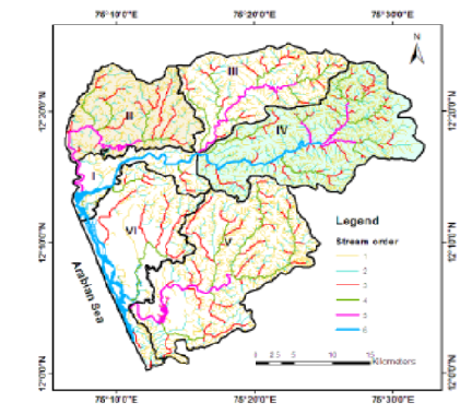
Objectives: This article examines the geohydrological behaviour of the Kariangote watershed and prioritizes its subwatersheds based on groundwater presence. Methods: Remote sensing and GIS techniques were used to study the morphometric and geomorphologic characteristic of the watershed. Six sub-watersheds were identified, and various morphometric and geomorphic parameters were calculated. Based on the relative importance to groundwater occurrence, sub-watersheds were prioritized by giving suitable weightage to morphometric and geomorphological units. Findings: Sub-watershed IV is the most deficit one and is given priority followed by III the next, V, II, I, and VI. Sub-watershed VI is with surplus groundwater and is given the last priority. Novelty: Higher priority should be given to conservation practices in sub-watersheds to prevent surface runoff and soil erosion and to increase groundwater levels. Sub-watersheds with highly permeable subsurface formation could be suggested for rainwater harvesting and artificial recharge of groundwater. Planning further groundwater development projects and managing watersheds would be aided by this study. Keywords: Morphometry; Coastal Alluvium; Flood Plain; Groundwater; Prioritization

References

  1. Balasubramanian A, Duraisamy K, Thirumalaisamy S, Krishnaraj S, Yatheendradasan RK. Prioritization of subwatersheds based on quantitative morphometric analysis in lower Bhavani basin, Tamil Nadu, India using DEM and GIS techniques. Arabian Journal of Geosciences. 2017;10(24). Available from: https://doi.org/10.1007/s12517-017-3312-6
  2. Choudhari PP, Nigam GK, Singh SK, Thakur S. Morphometric based prioritization of watershed for groundwater potential of Mula river basin, Maharashtra, India. Geology, Ecology, and Landscapes. 2018;2(4):256–267. Available from: https://doi.org/10.1080/24749508. 2018.1452482
  3. Gosain AK, Rao S. GIS-based technologies for watershed management. Current Science. 2004;87:948–953. Available from: https://www.jstor.org/stable/24109399
  4. Gautam PK, Singh DS, Kumar D, Singh AK. A GIS-based Approach in Drainage Morphometric Analysis of Sai River Basin, Uttar Pradesh, India. Journal of the Geological Society of India. 2020;95(4):366–376. Available from: https://doi.org/10.1007/s12594-020-1445-9
  5. Singh AP, Arya AK, Singh DS. Morphometric Analysis of Ghaghara River Basin, India, Using SRTM Data and GIS. Journal of the Geological Society of India. 2020;95(2):169–178. Available from: https://doi.org/10.1007/s12594-020-1406-3
  6. Bhattacharya RK, Chatterjee ND, Das K. Sub-watershed prioritization for assessment of soil erosion susceptibility in Kangsabati. A comparison between MCDM and SWAT models. 2020;734. Available from: https://doi.org/10.1016/j.scitotenv.2020.139474
  7. Khan I, Bali R, Agarwal KK, Kumar D, Singh SK. Morphometric Analysis of Parvati Basin, NW Himalaya: A Remote Sensing and GIS Based Approach. Journal of the Geological Society of India. 2021;97(2):165–172. Available from: https://doi.org/10.1007/s12594-021-1648-8
  8. Strahler AN. Quantitative geomorphology of drainage basins and channel networks. In: VTC., ed. Handbook of Applied Hydrology. McGraw Hill Book Company. 1964.
  9. Schumm SA. Evolution of drainage systems and slopes in badlands at Perth Ambos. New Jersey. Geological Society of America Bulletin. 1956;67:597–646. Available from: https://doi.org/10.1130/0016-7606(1956)67[597:eodsas]2.0.co;2
  10. Smith KG. Standards for grading texture of erosional topography. American Journal of Science. 1950;248(9):655–668. Available from: https://doi.org/10.2475/ajs.248.9.655
  11. Gayen S, Bhunia GS, Shi PK. Morphometric analysis of Kangshabati-Darkeswar interfluves area in West Bengal, India using ASTER DEM and GIS techniques. Journal of Geology and Geoscience. 2013;2(4):1–10. Available from: https://doi.org/10.4172/2329-6755.1000133
  12. Bali R, Agarwal KK, Ali SN, Rastogi SK, Krishna K. Drainage morphometry of Himalayan Glacio-fluvial basin, India: hydrologic and neotectonic implications. Environmental Earth Sciences. 2012;66(4):1163–1174. Available from: https://doi.org/10.1007/s12665-011-1324-1

Copyright

© 2023 Priya. This is an open-access article distributed under the terms of the Creative Commons Attribution License, which permits unrestricted use, distribution, and reproduction in any medium, provided the original author and source are credited. Published By Indian Society for Education and Environment (iSee

DON'T MISS OUT!

Subscribe now for latest articles and news.