• P-ISSN 0974-6846 E-ISSN 0974-5645

Indian Journal of Science and Technology

Article

Indian Journal of Science and Technology

Year: 2020, Volume: 13, Issue: 16, Pages: 1619-1629

Original Article

Unsupervised ISODATA algorithm classification used in the landsat image for predicting the expansion of Salem urban, Tamil Nadu

Received Date:15 April 2020, Accepted Date:09 April 2020, Published Date:07 June 2020

Abstract

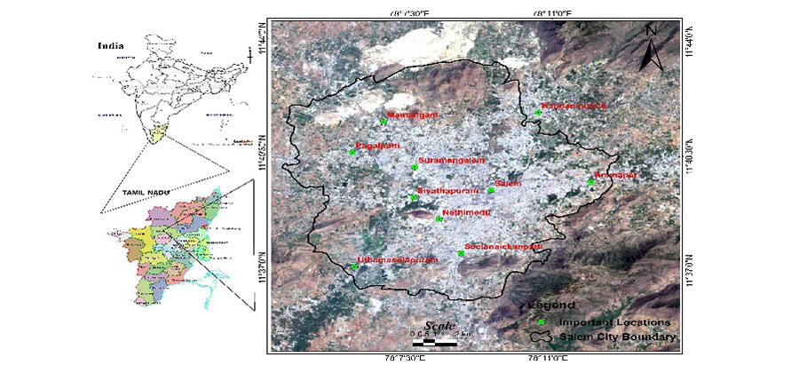
Objectives: To study the land cover change Salem city as a case study of urban expansion in India covering the span of 35 years from 1990 to 2025. Method: Remote sensing methodology is adopted to study the geographical land use changes occurred during the study period (year 1990- 2025). Landsat images of TM and ETM+ of Salem city area are collected from the USGS Earth Explorer website. After image pre-processing, unsupervised image classification has been performed to classify the images into different land use categories. Seven land use classes have been identified as road, urban (Build up), vegetation, water bodies, fallow land, mines and barren land. Classification accuracy is also estimated using the field knowledge obtained from field surveys. Findings: The obtained accuracy is between 83 to 86% of all the classes. Change detection analysis shows the built-up area has been increased by 1.49 km2 , vegetation area has been decreased by 11.55km2 . Application: Information on Urban growth, land use and land cover change study is very useful to local Government and Urban Planners for the betterment of the future plans of sustainable development of the city.

Keywords: Land use /Land cover; Urban Sprawl; Urbanization; Remote Sensing; Landsat data; Salem city

References

  1. Eastman J, Fulk M. Long Sequence Time Series Evaluation Using Standardized Principal Components. . Photogrammetric Engineering & Remote Sensing. 1993;59(8):1307–1312. Available from: http://worldcat.org/issn/00991112
  2. Shankar B. Chromium Pollution in the Groundwaters of an Industrial Area in Bangalore, India. Electronic Green Journal. 2009;26:305–310. doi: 10.1089/ees.2008.0043
  3. Rawat JS, Kumar M. Monitoring land use/cover change using remote sensing and GIS techniques: A case study of Hawalbagh block, district Almora, Uttarakhand, India. The Egyptian Journal of Remote Sensing and Space Science. 2015;18(1):77–84. doi: 10.1016/j.ejrs.2015.02.002
  4. Ismail MH, KJ. Satellite Data Classification Accuracy Assessment Based from Reference Dataset. World Academy of Science, Engineering and Technology. 2008;2(3):527–533. Available from: http://citeseerx.ist.psu.edu/viewdoc/download?doi=10.1.1.307.4674&rep=rep1&type=pdf
  5. Song C, Woodcock CE, Seto KC, Lenney MP, Macomber SA. Classification and Change Detection Using Landsat TM Data: When and How to Correct Atmospheric Effects. Remote Sensing of Environment. 2001;75(2):230–244. doi: 10.1016/s0034-4257(00)00169-3
  6. Vimala R, Marimuthu A. Spatial Temporal Expansion of Urban Sprawl in the Salem City of Tamil Nadu, India Using Geospatial Techniques. International Journal of Computer Application. 2016;6(2):22–27. Available from: https://rspublication.com/ijca/2016/april16/4.pdf
  7. Thomson AG, Fuller RM, Eastwood JA. Supervised versus unsupervised methods for classification of coasts and river corridors from airborne remote sensing. International Journal of Remote Sensing. 1998;19(17):3423–3431. doi: 10.1080/014311698214091
  8. Jensen JR. A Remote Sensing Perspective. In: Introductory Digital Image Processing. Upper Saddle River, NJ. Pearson Prentice Hall. 2005.
  9. Sundar ML, Prasath CA, Rosario HE, Tamilselvan K. Urban Sprawl Mapping and Land Use Change Detection Analysis. International Journal on Advanced Science, Engineering and Information Technology. 2019;9(1):281. doi: 10.18517/ijaseit.9.1.8080
  10. Shrivastava RJ, Gebelein JL. Land cover classification and economic assessment of citrus groves using remote sensing. ISPRS Journal of Photogrammetry and Remote Sensing. 2007;61:341–353. doi: 10.1016/j.isprsjprs.2006.10.003
  11. Mandal J, Ghosh N, Mukhopadhyay A. Urban Growth Dynamics and Changing Land-Use Land-Cover of Megacity Kolkata and Its Environs. Journal of the Indian Society of Remote Sensing. 2019;47(10):1707–1725. doi: 10.1007/s12524-019-01020-7

Copyright

© 2020 R, A, S, R. This is an open access article distributed under the terms of the Creative Commons Attribution License, which permits unrestricted use, distribution, and reproduction in any medium, provided the original author and source are credited. Published By Indian Society for Education and Environment (iSee)

DON'T MISS OUT!

Subscribe now for latest articles and news.