• P-ISSN 0974-6846 E-ISSN 0974-5645

Indian Journal of Science and Technology

Article

Indian Journal of Science and Technology

Year: 2023, Volume: 16, Issue: 20, Pages: 1477-1486

Original Article

Analysis on the Land Suitability for Coconut Cultivation using Geographic Information System

Received Date:06 June 2022, Accepted Date:26 January 2023, Published Date:19 May 2023

Abstract

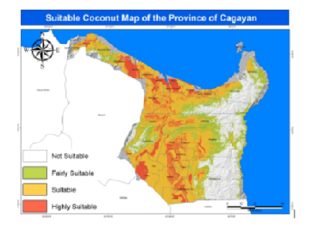
Objectives: This study developed a GIS-based approach for the spatial classification of land resources to assist planners to easily identify and increase areas for the cultivation of coconuts. Methods: The evaluation of land for its suitability application was a GIS-based multi-criteria evaluation involving guidelines on matching land quality diagnostics against crop requirements and assigning suitability rates for each land quality. Factors such as elevation, landform, soil drainage, slope, soil texture, and soil depth were used as parameters. Findings: Results showed that the existing coconut plantation is within the final suitability map developed. It revealed that around 420,000 hectares or 45.2% of the area considered in this study were found suitable locations for coconut production. Applications: Land suitability analysis for coconut cultivation using multi-criteria assessment in the GIS environment is a great tool for assessing and evaluating land in terms of its varying importance to decision-makers for sustainable agricultural production. Novelty: This study implemented spatial analysis in land evaluation that offered better land options in the study area.

Keywords: Land Suitability Analysis; Coconut Cultivation; Geographic Information System; Multiple Criteria; Spatial Analysis

References

  1. Agcaoili S. Geographic Information System-Based Suitability Analysis for Potential Shallow Tube-Well Irrigation Development. Recoletos Multidisciplinary Research Journal. 2019;6(2):35–49. Available from: https://doi.org/10.32871/rmrj1806.02.04
  2. Pilevar AR, Matinfar HR, Sohrabi A, Sarmadian F. Integrated fuzzy, AHP and GIS techniques for land suitability assessment in semi-arid regions for wheat and maize farming. Ecological Indicators. 2020;110:105887. Available from: https://doi.org/10.1016/j.ecolind.2019.105887
  3. Riza S, Sekine M, Kanno A, Yamamoto K, Imai T, Higuchi T. Land Suitability Analysis for Agricultural Land Use using Hyperscale DEM Data. AGRIVITA Journal of Agricultural Science. 2022;44(2):187–198. Available from: http://doi.org/10.17503/agrivita.v44i2.2985
  4. Khahro SH, Matori AN, Chandio IA, Talpur MAH. Data Preparation for GIS based Land Suitability Modelling: A Stepped Approach. E3S Web of Conferences. 2019;101:02001. Available from: https://doi.org/10.1051/e3sconf/201910102001
  5. Pan G, Pan J. Research in Crop Land Suitability Analysis Based on GIS. In: L, D, C, Y., eds. Computer and Computing Technologies in Agriculture V. (Vol. 369, pp. 314-325) Springer Berlin Heidelberg. 2012.
  6. Chen Y, Shahbaz K, Paydar Z. Irrigation Intensification or Extensification Assessment: A GIS-Based Spatial Fuzzy Multi-Criteria Evaluation. Proceedings of the 8th International Symposium on Spatial Accuracy Assessment in Natural Resources and Environmental Sciences. 2008. Available from: https://www.researchgate.net/publication/267682956_Irrigation_Intensification_or_Extensification_Assessment_A_GIS-Based_Spatial_Fuzzy_Multi-Criteria_Evaluation
  7. Bydekerke L, Ranst EV, Vanmechelen L, Groenemas R. Land suitability assessment for cherimoya in southern Ecuador using expert knowledge and GIS. Agriculture, Ecosystem & Environment. 1998;69(2):90–95. Available from: https://doi.org/10.1016/S0167-8809(98)00090-5
  8. Khan MA, Ahmad R, Khan HH. Multi-Criteria Land Suitability Analysis for Agriculture Using AHP and Remote Sensing Data of Northern Region India. Geographic Information System [Working Title. 2022. Available from: https://cdn.intechopen.com/pdfs/80925.pdf
  9. Amini S, Rohani A, Aghkhani MH, Abbaspour-Fard MH, Asgharipour MR. Assessment of land suitability and agricultural production sustainability using a combined approach (Fuzzy-AHP-GIS): A case study of Mazandaran province, Iran. Information Processing in Agriculture. 2020;7(3):384–402. Available from: https://doi.org/10.1016/j.inpa.2019.10.001
  10. Cuong N. Integration of GIS and Decision Tree in Land Evaluation for Coconut Trees in Mo Cay Nam District. VNU Journal Of Science: Earth And Environmental Sciences. 2018;(1) 34. Available from: https://doi.org/10.25073/25881094/vnuees.421
  11. Geetha GP, Dhumgond P, Shruti Y, Parama R, Sathish VR, A. Study of Land Evaluation in Giddadapalya Microwatershed, Tumkur District. Journal of Pharmacognosy and Phytochemistry. 2017;6(5):2123–2130. Available from: https://www.phytojournal.com/archives/2017.v6.i5.1953/study-of-land-evaluation-in-giddadapalya-microwatershed-tumkur-district
  12. Chandrakala M, Srinivasan R, Prasad B, NKV, SK, Hegde R, et al. Land Suitability Evaluation for Pigeon Pea in Semi-arid Land. Communications in Soil Science and Plant Analysis. 53(6):675–687. Available from: https://doi.org/10.1080/00103624.2022.2028807
  13. S GN, Sonam B, Munish K, S AV. Land suitability assessment for Banana and Pine Apple: A decision making approach using geo-spatial technology. Journal of Soil and Water Conservation Year. 2017;(3) 212–220. Available from: https://doi.org/10.5958/2455-7145.2017.00033.9
  14. Longwell TJ, Parks WL, Springer ME. Moisture Characteristics of Tennessee Soils. 1963. Available from: https://trace.tennessee.edu/utk_agbulletin/303
  15. Campling P, Gobin A, Feyen J. Logistic Modeling to Spatially Predict the Probability of Soil Drainage Classes. Soil Science Society of America Journal. 2002;66(4):1390–1401. Available from: https://doi.org/10.2136/sssaj2002.1390
  16. Wells KL. Soil drainage - effects on crop production. Soil Science news and Views. 1980;1(6). Available from: http://uknowledge.uky.edu/pss_views/152
  17. Canja LH, Magat SS. Coconut-coffee cropping model. Coconut Intercropping guide. 2006;(6) 1–10. Available from: https://www.yumpu.com/en/document/read/46581338/coconut-coffee-robusta-excelsa-arabica-cropping-model
  18. Aymen AT, Al-Husban Y, Farhan I. Land suitability evaluation for agricultural use using GIS and remote sensing techniques: The case study of Ma’an Governorate. The Egyptian Journal of Remote Sensing and Space Science. 2021;24(1):109–117. Available from: https://doi.org/10.1016/j.ejrs.2020.01.001
  19. Zhang J, Su Y, Wu J, Liang H. GIS based land suitability assessment for tobacco production using AHP and fuzzy set in Shandong province of China. Computers and Electronics in Agriculture. 2015;114:202–211. Available from: https://doi.org/10.1016/j.compag.2015.04.004
  20. Zabihi AH, Ahmad I, Vogeler MN, Said M, Golmohammadi B, Golein M, et al. Land suitability procedure for sustainable citrus planning using the application of the analytical network process approach and GIS. Computers and Electronics in Agriculture. 2015;117:114–126. Available from: https://doi.org/10.1016/j.compag.2015.07.014

Copyright

© 2023 Agcaoili. This is an open-access article distributed under the terms of the Creative Commons Attribution License, which permits unrestricted use, distribution, and reproduction in any medium, provided the original author and source are credited. Published By Indian Society for Education and Environment (iSee)

DON'T MISS OUT!

Subscribe now for latest articles and news.