• P-ISSN 0974-6846 E-ISSN 0974-5645

Indian Journal of Science and Technology

Article

Indian Journal of Science and Technology

Year: 2023, Volume: 16, Issue: 46, Pages: 4456-4468

Original Article

Application of Remote Sensing and GIS Techniques for Identification of Changes in Land Use and Land Cover (LULC): A Case Study

Received Date:06 October 2023, Accepted Date:19 October 2023, Published Date:20 December 2023

Abstract

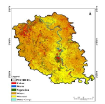
Objective: This study investigates the Spatial temporal changes of LULC in Mathura district of Uttar Pradesh, India, over the past 30 years (1990 to 2020). The study uses Landsat-5, Landsat-7 as well as Landsat-8 OLI images and GIS technique. Methods: The images are classified into LULC classes using a random forest classifier. The LULC changes are analyzed using a change detection analysis. The results of the change detection analysis were visualized using GIS. Confusion matrix is used for comparing the Crop classification during 1990–2020. User accuracy, consumer accuracy, producer accuracy, overall accuracy and kappa coefficient are used to compare the study of approximately three decades from 1990 to 2020. Findings: The classification of LULC is done into six classes i.e., urban, water bodies, vegetation, wheat, mustard and other crops. The results show that there are significant changes in LULC over the past 30 years. In the year 1990, 70.1 % accuracy and kappa 61.61 are obtained. In the year 2000, 70.8 % accuracy and kappa 63.02 are obtained. In the year 2010, 71.3% accuracy and kappa 64.8 is obtained. In the year 2020, 84% accuracy and kappa 80 are obtained. Novelty: In traditional mapping is not feasible, multi temporal satellite imagery can offer the crucial measurement of spatial and temporal phenomena for the research area. The study shows that the predominant land use in the area under investigation is vegetation. Less agricultural activity occurred between 2000 and 2010, which increased the amount of land covered by vegetation. The importance of monitoring LULC changes in order to understand the effects of these variations on the society as well as environment.

Keywords: Spatio­temporal changes, LULC, Landsat, GIS, agricultural expansion and urbanization

References

  1. Chughtai AH, Abbasi H, Karas IR. A review on change detection method and accuracy assessment for land use land cover. Remote Sensing Applications: Society and Environment. 2021;22:100482. Available from: https://doi.org/10.1016/j.rsase.2021.100482
  2. Baranwal E, Ahmad S, Baghel SS. Spatiotemporal Analysis for Urban Pattern Evolution in Sacred District Mathura of India through K-means Classification. International Journal of Town Planning and Management. 2019;5(1):26–35. Available from: https://doi.org/10.37628/jtpm.v5i1.466
  3. Wang X, Xin L, Tan M, Li X, Wang J. Impact of spatiotemporal change of cultivated land on food-water relations in China during 1990–2015. Science of The Total Environment. 2020;716:137119. Available from: https://doi.org/10.1016/j.scitotenv.2020.137119
  4. Yan J, Gao S, Xu M, Su F. Spatial-temporal changes of forests and agricultural lands in Malaysia from 1990 to 2017. Environmental Monitoring and Assessment. 2020;192(12):1–6. Available from: https://doi.org/10.1007/s10661-020-08765-6
  5. Alijani Z, Hosseinali F, Biswas A. Spatio-temporal evolution of agricultural land use change drivers: A case study from Chalous region, Iran. Journal of Environmental Management. 2020;262:110326. Available from: https://doi.org/10.1016/j.jenvman.2020.110326
  6. Nepal P, Khanal NR, Zhang Y, Paudel B, Liu L. Land use policies in Nepal: An overview. Land Degradation & Development. 2020;31(16):2203–2212. Available from: https://doi.org/10.1002/ldr.3621
  7. Gondwe JF, Lin S, Munthali RM. Analysis of Land Use and Land Cover Changes in Urban Areas Using Remote Sensing: Case of Blantyre City. Discrete Dynamics in Nature and Society. 2021;2021:1–17. Available from: https://doi.org/10.1155/2021/8011565
  8. Kumar P, Dobriyal M, Kale A, Pandey AK. Temporal dynamics change of land use/land cover in Jhansi district of Uttar Pradesh over past 20 years using LANDSAT TM, ETM+ and OLI sensors. Remote Sensing Applications: Society and Environment. 2021;23:100579. Available from: https://doi.org/10.1016/j.rsase.2021.100579
  9. Rahman ML, Rahman SH. Detection of Land Use Land Cover Changes Using Remote Sensing and GIS Techniques in a Secondary City in Bangladesh. Grassroots Journal of Natural Resources. 2021;4(3):132–146. Available from: https://doi.org/10.33002/nr2581.6853.040311
  10. Seyam MMH, Haque MR, Rahman MM. Identifying the land use land cover (LULC) changes using remote sensing and GIS approach: A case study at Bhaluka in Mymensingh, Bangladesh. Case Studies in Chemical and Environmental Engineering. 2023;7:1–12. Available from: https://doi.org/10.1016/j.cscee.2022.100293
  11. Zarin T, Esraz-Ul-Zannat M. Assessing the potential impacts of LULC change on urban air quality in Dhaka city. Ecological Indicators. 2023;154:1–19. Available from: https://doi.org/10.1016/j.ecolind.2023.110746
  12. Faiyetole AA, Adewumi VA. Urban expansion and transportation interaction: Evidence from Akure, southwestern Nigeria. Environment and Planning B: Urban Analytics and City Science. 2023. Available from: https://doi.org/10.1177/23998083231169427
  13. Baig IA, Irfan M, Salam MA, Işik C. Addressing the effect of meteorological factors and agricultural subsidy on agricultural productivity in India: a roadmap toward environmental sustainability. Environmental Science and Pollution Research. 2023;30(6):15881–15898. Available from: https://doi.org/10.1007/s11356-022-23210-6
  14. Negese A. Impacts of Land Use and Land Cover Change on Soil Erosion and Hydrological Responses in Ethiopia. Applied and Environmental Soil Science. 2021;2021:1–10. Available from: https://doi.org/10.1155/2021/6669438
  15. Prabu P, Dar MA. Land-use/cover change in Coimbatore urban area (Tamil Nadu, India)—a remote sensing and GIS-based study. Environmental Monitoring and Assessment. 2018;190(8):1–4. Available from: https://doi.org/10.1007/s10661-018-6807-z
  16. Zadbagher E, Becek K, Berberoglu S. Modeling land use/land cover change using remote sensing and geographic information systems: case study of the Seyhan Basin, Turkey. Environmental Monitoring and Assessment. 2018;190(8). Available from: https://doi.org/10.1007/s10661-018-6877-y
  17. Wang X, Xin L, Tan M, Li X, Wang J. Impact of spatiotemporal change of cultivated land on food-water relations in China during 1990–2015. Science of The Total Environment. 2020;716:137119. Available from: https://doi.org/10.1016/j.scitotenv.2020.137119
  18. Choudhary K, Boori MS, Kupriyanov A. Spatial modelling for natural and environmental vulnerability through remote sensing and GIS in Astrakhan, Russia. The Egyptian Journal of Remote Sensing and Space Science. 2018;21(2):139–147. Available from: https://doi.org/10.1016/j.ejrs.2017.05.003

Copyright

© 2023 Gupta et al. This is an open-access article distributed under the terms of the Creative Commons Attribution License, which permits unrestricted use, distribution, and reproduction in any medium, provided the original author and source are credited. Published By Indian Society for Education and Environment (iSee)

DON'T MISS OUT!

Subscribe now for latest articles and news.