Indian Journal of Science and Technology
Year: 2023, Volume: 16, Issue: 35, Pages: 2822-2834
Original Article
Atul M Jethe1*, Lalit M Thakare2
1Department of Geography, C.T. Bora College, Shirur, Pune, Maharashtra, 412210, India
2Department of Geography, Sir Parashurambhau College, Pune, 411030, Maharashtra, India
*Corresponding Author
Email: [email protected]
Received Date:28 February 2023, Accepted Date:11 August 2023, Published Date:19 September 2023
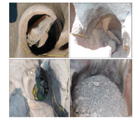
Objectives: The present research aims to study the hydrogeomorphology, mechanism of channel morphology, development and distribution of the potholes in the Kukadi River, Maharashtra. To ascertain the size and shape relationship of the potholes. To find out the recent anthropogenic effects on the bedrock lithology of the Kukadi River. Methods: The comprehensive methods of Remote Sensing and GIS techniques are used to determine hydraulic geometry and pothole development. Six geomorphological sites were selected for section-based profiling. The measurements were taken by dumpy level, GPS and total station survey. Field survey was conducted to determine the geometry of the size shape and depth of the potholes. Pebbles and grinding tools within the potholes were also collected to analyse the capacity and role of joints, cracks and fractures in the development of potholes. All maps were prepared in a GIS environment. Findings: The present study reveals the mechanism of pothole development at six major sites. Section-based profiling highlights the dominance of hydrodynamics, stream energy and capacity. The hydraulic geometry of the Kukadi river conforms to the relationship between the depth and diameter of potholes. It also ascertains the role of joints, cracks and fractures at riverbeds in the development of potholes. Thus Depth and diameter of the Kukadi river are almost maintained by lithology. Based on shape Honewadi (585 MSL) 29.03% (31) potholes are irregular in shape, Gadilgaon(575 MSL) is 27.08%(48) rounded, Gunore(570 MSL) is 26.78% (15) irregular, Dongargaon(565 MSL) 25.01%(44), Kohokadi (560 MSL) 28.26% (13)irregular while Mhase(565 MSL)39.95% (13) Club shape in nature Novelty: The scope of the present research is to provide a comprehensive assessment of the hydraulic geometry and potholes development on bedrock channel, which has received limited attention in previous studies. The study employs a multidisciplinary approach that combines field observation, hydrological and geomorphological measurement.Thus the study highlights their geoenvironmental, ecological and cultural values in the context of sustainable river management and conservation
Keywords: Potholes; Hydraulic Geometry; Hydrodynamics; Geometrical Shapes; Depth And Diameter Relationship; Remote Sensing and GIS
© 2023 Jethe & Thakare. This is an open-access article distributed under the terms of the Creative Commons Attribution License, which permits unrestricted use, distribution, and reproduction in any medium, provided the original author and source are credited. Published By Indian Society for Education and Environment (iSee)
Subscribe now for latest articles and news.