• P-ISSN 0974-6846 E-ISSN 0974-5645

Indian Journal of Science and Technology

Article

Indian Journal of Science and Technology

Year: 2024, Volume: 17, Issue: 24, Pages: 2508-2518

Original Article

Bankline Migration Analysis of Brahmaputra River in Morigaon District, Assam using Automated Method

Received Date:12 April 2024, Accepted Date:22 May 2024, Published Date:12 June 2024

Abstract

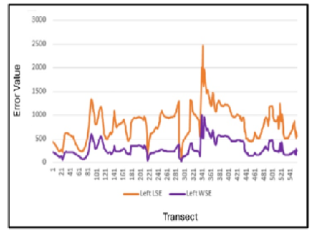
Objectives: The study examines spatio-temporal changes, forecasts bankline migration and seeks to determine its underlying causes and consequences. Methods: Bankline change detection was performed through comprehensive GPS-based field surveys and remote sensing data, validated with ground-based data. The NDWI and MNDWI used to delineate the bankline positions from 1988-2022, with temporal changes estimated using the DSAS model. Findings: The left and right riverbank have been divided into three exclusive zones to find out which zone is severely erosion and accretion prone regions for zone-wise exclusive analysis. In the analysis, it has noticed that the left bank experiencing severe bank erosion and the right bank is experiencing an accretion rate increase in the last few decades. The LRR statistics show that the erosion rate in the left bank (81.17 m/y) is significantly high with an accretion rate of 0 m/y in the observed area. On the other hand, in the right bank, the rate of erosion is 83.59 m/y and the rate of accretion is 68.45 m/y. The left bank’s erosion is notably high. Additionally, the erosion rate is severe in the zone C (118.22 m/y) of left bank line. In this zone, the erosion rate hiked by 59.58 m/y in 34 years. Novelty: This study addresses a significant gap in understanding the riverbank shifting dynamics along with its causes and socio-economic impact of the Brahmaputra River in the Morigaon district. By combining the hydrodynamic modelling and cause-effect analysis, it provides a comprehensive analysis of bankline migration patterns and their causes and consequences. Unlike previous research, which primarily focuses on bankline migration rates and land use changes, this research work uniquely explores the direct impact of riverbank shifting on local communities. The integration of advanced predictive models with detailed primary and secondary data analysis offers novel insights crucial for efficient flood management and policy making practices.

Keywords: Normalised Difference Water Index (NDWI), Modified Normalized Difference Index (MNDWI), Digital Shoreline Analysis System (DSAS), EPR and LRR Model, Bankline Shift

References

  1. Rajib A, Zheng Q, Golden HE, Wu Q, Lane CR, Christensen JR, et al. The changing face of floodplains in the Mississippi River Basin detected by a 60-year land use change dataset. Scientific Data. 2021;8:1–11. Available from: https://www.nature.com/articles/s41597-021-01048-w
  2. Ritu SM, Sarkar SK, Zonaed H. Prediction of Padma river bank shifting and its consequences on LULC changes. Ecological Indicators. 2023;156:1–15. Available from: https://doi.org/10.1016/j.ecolind.2023.111104
  3. Hasanuzzaman M, Gayen A, SMH, Shit PK. Spatial modeling of river bank shifting and associated LULC changes of the Kaljani River in Himalayan foothills. Stochastic Environmental Research and Risk Assessment . 2022;36:563–582. Available from: https://doi.org/10.1007/s00477-021-02147-1
  4. Sarkar R, Sarkar P, Biswas G. Channel Shifting Behaviour and Delineation of Channel Migration Zone: A Study on Nagar River of West Bengal, India. International Journal of Science and Research. 2019;8(11):706–716. Available from: https://www.ijsr.net/getabstract.php?paperid=ART20202616
  5. Berkovich KM, Zlotina LV, Turykin LA. Riverbank erosion: factors, mechanism, human activity. Geomorphology . 2019;2:3–17. Available from: https://doi.org/10.31857/S0435-4281201923-17
  6. Saadon A, Abdullah J, Muhammad NS, Ariffin J, Julien PY. Predictive models for the estimation of riverbank erosion rates. Catena. 2021;196:1–12. Available from: https://doi.org/10.1016/j.catena.2020.104917
  7. Huang S, Xia J, Wang Y, Wang W, Zeng S, She D, et al. Coupling Machine Learning Into Hydrodynamic Models to Improve River Modeling With Complex Boundary Conditions. Water Resources Research. 2022;58(10). Available from: https://doi.org/10.1029/2022WR032183
  8. Debnath J, Sahariah D, Lahon D, Nath N, Chand K, Meraj G, et al. Assessing the impacts of current and future changes of the planforms of river Brahmaputra on its land use-land cover. Geoscience Frontiers. 2023;14(4):1–23. Available from: https://doi.org/10.1016/j.gsf.2023.101557
  9. Hossen MF, Sultana N. Shoreline change detection using DSAS technique: Case of Saint Martin Island, Bangladesh. Remote Sensing Applications: Society and Environment. 2023;30. Available from: https://doi.org/10.1016/j.rsase.2023.100943
  10. Debnath J, Sahariah D, Saikia A, Meraj G, Nath N, Lahon D, et al. Shifting Sands: Assessing Bankline Shift Using an Automated Approach in the Jia Bharali River, India. Land . 2023;12(3):1–26. Available from: https://doi.org/10.3390/land12030703
  11. Rahman MS, Gain A. Adaptation to river bank erosion induced displacement in Koyra Upazila of Bangladesh. Progress in Disaster Science. 2020;5:1–8. Available from: https://doi.org/10.1016/j.pdisas.2019.100055
  12. Santos CAG, Nascimento TVMd, Mishra M, Silva RMd. Analysis of long- and short-term shoreline change dynamics: A study case of João Pessoa city in Brazil. Science of The Total Environment. 2021;769. Available from: https://doi.org/10.1016/j.scitotenv.2020.144889
  13. Quang DN, Ngan VH, Tam HS, Viet NT, Tinh NX, Tanaka H. Long-Term Shoreline Evolution Using DSAS Technique: A Case Study of Quang Nam Province, Vietnam. Journal of Marine Science and Engineering. 2021;9(10):1–18. Available from: https://doi.org/10.3390/jmse9101124
  14. Hossain MS, Yasir M, Wang P, Ullah S, Jahan M, Hui S, et al. Automatic shoreline extraction and change detection: A study on the southeast coast of Bangladesh. Marine Geology. 2021;441. Available from: https://doi.org/10.1016/j.margeo.2021.106628
  15. Barik G, Guru B, Sangma F. Shoreline Changes Analysis and Forecast Using Digital Shoreline Assessment System 5.0: Evidences from Parts of East Coast of India. Journal of the Indian Society of Remote Sensing. 2021;49(11):2815–2830. Available from: https://dx.doi.org/10.1007/s12524-021-01424-4
  16. Pal D, Bhattacharji M. Assessment of Bankline Shifting and Erosion-Deposition dynamics of Kangsabati River in Downstream of Mukutmanipur Dam, Rarh Bengal. RESEARCH REVIEW International Journal of Multidisciplinary. 2022;7(8):36–48. Available from: https://dx.doi.org/10.31305/rrijm.2022.v07.i08.006
  17. Rosli NAM, Ibrahim SL, Yusoff SH. Effects of Soil Erodibility on Riverbank Erosion and Failures. IIUM Engineering Journal. 2024;25(1):115–127. Available from: https://dx.doi.org/10.31436/iiumej.v25i1.2959

Copyright

© 2024 Singh & Bhattacharjee. This is an open-access article distributed under the terms of the Creative Commons Attribution License, which permits unrestricted use, distribution, and reproduction in any medium, provided the original author and source are credited. Published By Indian Society for Education and Environment (iSee)

DON'T MISS OUT!

Subscribe now for latest articles and news.