Indian Journal of Science and Technology
DOI: 10.17485/IJST/v17i12.2343
Year: 2024, Volume: 17, Issue: 12, Pages: 1129-1142
Original Article
G Vinuja1, N Bharatha Devi2*, G Aloy Anuja Mary3
1Research Scholar, Department of Computer Science and Engineering, Saveetha School of Engineering, Saveetha Institute of Medical and Technical Sciences, Saveetha University, Chennai, Tamil Nadu, India
2Associate Professor, Department of Computer Science and Engineering, Saveetha School of Engineering, Saveetha Institute of Medical and Technical Sciences, Saveetha University, Chennai, Tamil Nadu, India
3Professor, Department of Electronics and Communication Engineering, VelTech Rangarajan Dr. Sagunthala R&D Institute of Science and Technology, Avadi, Chennai, Tamil Nadu, India
*Corresponding Author
Email: [email protected]
Received Date:15 September 2023, Accepted Date:20 February 2024, Published Date:14 March 2024
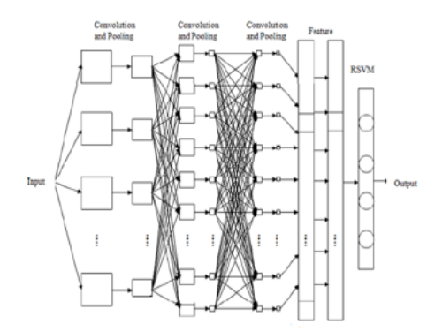
Objective: To effectively analyze diverse satellite images and derive valuable insights, it's crucial to employ efficient methods for classification and image processing. However, due to imperfections in image formats and sensor data, satellite imagery often contains flaws and inaccuracies, requiring extra steps to enhance its quality. The proposed solution involves two key techniques: segmenting the input image using a Hybrid HRSVM-CNN and classifying the resulting high-resolution remote sensing image using a Convolutional Neural Network. This combined approach addresses the challenges posed by image inconsistencies and aims to improve the accuracy and efficiency of current methods for satellite image analysis. Methods: In this research, a high-resolution Support Vector Machine-Convolutional Neural Network (Hybrid HRSVM-CNN) and texture characteristics are used to create an automated land identification method for satellite Remote sensing (RS) images. This approach's main focus is segmentation using the Bendlet Transform and Improved Chan-Vese, and it also does classification using a Hybrid HRSVM-CNN based on feature extraction and gray-level co-occurrence matrix algorithm. Findings: The proposed classification method's accuracy was evaluated against several other classification algorithms, including Semi-Supervised Graph Based Method (SSG), Conditional Random Fields (CRF), k-Nearest Neighbor (KNN), and Bi-layer Graph-based Learning (BLGL), Support Vector Machine (SVM), and Artificial Neural Networks (ANN). When compared with existing methods, the findings of the proposed method display excellent accuracy of 98.83%. Novelty: To start, an adaptive median filter is used to pre-process the satellite Remote sensing images, removing unwanted noises and other impacts. Following pre-processing, the image is segmented using the Bendlet Transform and Improved Chan-Vese algorithms. Gray-level co-occurrence matrix is utilized to extract texture information, and the Hybrid HRSVM-CNN is then used to categorize the various types of land. These applications frequently have a variety of issues that affect the categorization accuracy. A few significant factors, like location, irregularity, form, and diameter, reduce the process's overall accuracy. This research focuses on presenting a unique Land-Cover classification model in order to address such problems. The UC Merced Land Use dataset was considered in this research.
Keywords: Bendlet Transform and Improved ChanVese Segmentation, Hybrid HRSVMCNN, Land detection system, Satellite remote sensing images, Adaptive median filter, Gray level cooccurrence matrix
© 2024 Vinuja et al. This is an open-access article distributed under the terms of the Creative Commons Attribution License, which permits unrestricted use, distribution, and reproduction in any medium, provided the original author and source are credited. Published By Indian Society for Education and Environment (iSee)
Subscribe now for latest articles and news.


