Indian Journal of Science and Technology
Year: 2024, Volume: 17, Issue: 17, Pages: 1791-1799
Original Article
Monisha Linkesh1*, Minakshi Ghorpade1, Pratibha Prasad1
1Assistant Professor, Department of Information Technology, Thakur College of Engineering and Technology, Mumbai, Maharashtra, India
*Corresponding Author
Email: [email protected]
Received Date:15 February 2024, Accepted Date:27 March 2024, Published Date:24 April 2024
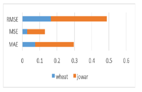
Objectives: The objective of this study is to improve the accuracy of crop yield prediction models, specifically focusing on wheat and jowar crops in Maharashtra during the Rabi season, by integrating Landsat and Sentinel satellite data with meteorological parameters. Methods: The study utilizes Landsat 8 and Sentinel satellite datasets covering Maharashtra State. Atmospheric correction is applied to extract surface properties, followed by wavelet-based fusion to combine the images. Normalized Difference Vegetation Index (NDVI) is calculated and combined with meteorological parameters using ensemble learning techniques, including Random Forest and Ada-Boost algorithms. Comparative analysis is conducted against existing models, considering parameters such as Mean Absolute Error (MAE), Mean Squared Error (MSE), and Root Mean Squared Error (RMSE). Findings: Significant findings reveal that the proposed methodology outperforms existing models, achieving lower MAE, MSE, and RMSE values for wheat and jowar yield predictions. Additionally, our research highlights the superiority of wheat production over jowar in the Rabi season, based on comprehensive analysis of crop yield predictions. Novelty: This study introduces a novel approach that integrates multiple data sources and employs ensemble learning techniques to enhance crop yield prediction accuracy. By combining Landsat and Sentinel satellite data with meteorological parameters, our methodology provides a more comprehensive understanding of crop growth dynamics, leading to more reliable predictions compared to existing methods.
Keywords: Satellite imagery, Machine learning, Normalized Difference Vegetation Index, Fusion, Ensemble learning
© 2024 Linkesh et al. This is an open-access article distributed under the terms of the Creative Commons Attribution License, which permits unrestricted use, distribution, and reproduction in any medium, provided the original author and source are credited. Published By Indian Society for Education and Environment (iSee)
Subscribe now for latest articles and news.


