Indian Journal of Science and Technology
DOI: 10.17485/IJST/v16i12.2202
Year: 2023, Volume: 16, Issue: 12, Pages: 894-902
Original Article
Ketan A Salunke1*, Abhaykumar S Wayal2
1Research Scholar, Department of Civil and Environmental Engineering, Veermata Jijabai Technological Institute, Mumbai, 400019, India
2Associate Professor, Department of Civil and Environmental Engineering, Veermata Jijabai Technological Institute, Mumbai, 400019, India
*Corresponding Author
Email: [email protected]
Received Date:16 November 2022, Accepted Date:28 February 2023, Published Date:27 March 2023
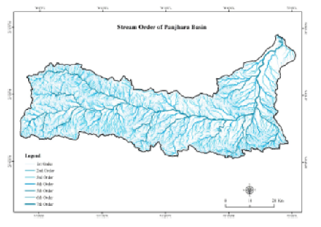
Objectives: Geomorphological changes that occur within a watershed have an influence on the availability and scarcity of water. As a consequence, a quantitative analysis of the watershed geometry is necessary to ascertain the impact of geomorphological processes on the catchment’s hydrology. Methods: Remote sensing (RS) and geographic information systems (GIS)- based strategies have gained in popularity recently because they help strategists and decision-makers make precise and effective decisions. The Panjhara River basin, tributary of Tapi River was selected for this study. The research demonstrates that, for improved planning and maintenance, GIS and RS data may be utilized to analyze and approximatively measure the duration and pace of erosional activities in a Panjhara River basin. The technique uses a 30-meter shuttle radar topography mission digital elevation model (SRTMDEM) and Survey of India toposheet for efficient and quick extraction of morphometric data and hypsometric analysis. Findings: The linear, areal, and relief aspects of the Panjhara River catchment were subjected to the twentysix morphometric criteria. The Re, Rc, and Ff all imply an elongated basin form. According to statistical study, there is a strong correlation between stream order and stream number as well as between stream order and stream length. The shape of the hypsometric curves and the findings of the computed hypsometric integrals represent the erosive phases of the Panjhara River basin. Novelty: The research finds that stakeholders involved in watershed development and management initiatives may find the results of morphometric and hypsometric analyses valuable.
Keywords: Morphometric Analysis; Hypsometric Analysis; Stream; GIS
© 2023 Salunke & Wayal. This is an open-access article distributed under the terms of the Creative Commons Attribution License, which permits unrestricted use, distribution, and reproduction in any medium, provided the original author and source are credited. Published By Indian Society for Education and Environment (iSee)
Subscribe now for latest articles and news.