Indian Journal of Science and Technology
Year: 2020, Volume: 13, Issue: 32, Pages: 3237-3247
Systematic Review
J Saranya1, N Thenmozhi2*
1Department of Computer Science, Government Arts and Science College, Coimbatore,Tamil Nadu, India
2Assistant Professor, PG and Research Department of Information Technology, Government
of Computer Science, Coimbatore, Tamil Nadu, India
*Corresponding Author
Email: [email protected]
Received Date:07 May 2020, Accepted Date:16 July 2020, Published Date:01 September 2020
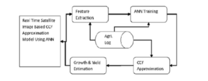
Objective: To improve the performance of an efficient satellite image based CCF (Color, Climate, Flow) approximation model is presented in this article. Method: We attempted for plant growth estimation and yield estimation using artificial neural networks. The model receives the satellite images and preprocesses to improve the quality of the image. From the quality improved image, the method extracts the color values. Further, the features like climate and flow features from the data set of the region have been extracted. Using these features, for different time window, the method generates number of neurons and initializes them with the set of features. The set of images from the data set are used to extract several features and used to train the network. The classification is performed according to the same set of features obtained from input satellite image and the other features of the region at current window. The method estimates CCF plant growth and yield support measures as result.Based on these values, the yield estimation is performed. Result: The proposed method improves the performance of plant growth up to 97.25 and the yield estimation performance is increased up to 985 which is higher than previous approaches. Provide comparative estimation. Novelty: The proposed CCF model consider color, climate and features in plant growth estimation which differ from other approaches by considering maximum features obtained from satellite images as well as features collected from ground truth in different time stamp.
Keywords: Sugarcane yield; plant growth; ANN; CCF model; feature approximation; satellite images; CCF support
© 2020 Saranya & Thenmozhi.This is an open-access article distributed under the terms of the Creative Commons Attribution License, which permits unrestricted use, distribution, and reproduction in any medium, provided the original author and source are credited. Published By Indian Society for Education and Environment (iSee).
Subscribe now for latest articles and news.